Mynd:Position of Eysturoy on Faroe map.png
Jump to navigation
Jump to search

Stødd av hesi forskoðan: 398 × 599 pixels. Aðrar upploysnir: 159 × 240 pixels | 319 × 480 pixels | 688 × 1.035 pixels.
Upprunafíla (688 × 1.035 pixel, stødd fílu: 19 KB, MIME-slag: image/png)
Samandráttur
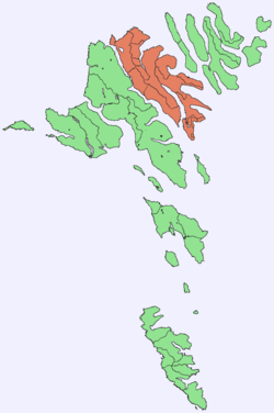
| Frágreiðing | Position of Eysturoy, Faroe Islands |
| Dagur | 11 september 2005 (original upload date) |
| Kelda | No machine-readable source provided. Own work assumed (based on copyright claims). |
| Høvundur | No machine-readable author provided. Arne List assumed (based on copyright claims). |
Lisensur
| I, the copyright holder of this work, release this work into the public domain. This applies worldwide. In some countries this may not be legally possible; if so: I grant anyone the right to use this work for any purpose, without any conditions, unless such conditions are required by law. |
Søgan hjá fíluni
Trýst á dato/tíð fyri at síggja fíluna, sum hon sá út tá.
| Dagur/Tíð | Lítil mynd | Dimensjónir | Brúkari | Viðmerking | |
|---|---|---|---|---|---|
| streymur | 11. sep 2005 kl. 16:00 | | 688 × 1.035 (19 KB) | wikimediacommons>Arne List | *Position of Eysturoy, Faroe Islands |
Nýtsla av fílu
Fylgjandi síða slóðar til hesa fílu: